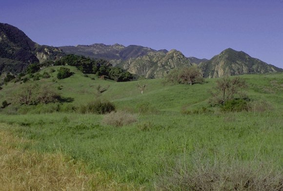
 This
lovely park nestled in a valley in the middle of Malibu Canyon
has been a favorite weekend spot of city dwellers for years.
Located just 25 miles from downtown Los Angeles, Malibu Creek
State Park has over 4,000 acres of hiking, fishing, bird watching,
and horseback activities. There are 15 miles of steamside trails
through oak and sycamore woodlands and chaparral covered slopes.
The park was the center of the Chumash Native American life
for centuries and was used to film many outdoor scenes for DQMW.
The most famous being the Honey and Berries Cave from the episode
The Abduction and the "wall" that was used for a mine
where Matthew once worked.
This
lovely park nestled in a valley in the middle of Malibu Canyon
has been a favorite weekend spot of city dwellers for years.
Located just 25 miles from downtown Los Angeles, Malibu Creek
State Park has over 4,000 acres of hiking, fishing, bird watching,
and horseback activities. There are 15 miles of steamside trails
through oak and sycamore woodlands and chaparral covered slopes.
The park was the center of the Chumash Native American life
for centuries and was used to film many outdoor scenes for DQMW.
The most famous being the Honey and Berries Cave from the episode
The Abduction and the "wall" that was used for a mine
where Matthew once worked.
Driving
Directions
Take 101 Frwy to Las Virines/Malibu Canyon. Go south about 3.5
miles to the park entrance. From PC (CA 1) go north on Las Virgenes/Malibu
Canyon about 6 miles to park entrance on your left. You can
park in (day-use fee) or outside of the park. From the last
parking lot, ride south to a road marked Authorized Vehicles
Only (Crags Road). There are two other trailheads in Malibu
State Park. 1. - Take 101 north to Liberty Canyon Rd. Go south
1 mile to Park Vista and park there.This is the trailhead for
Liberty Canyon Trail. 2. - Take Las Virines south, turn right
on Mulholland Dr. The Grasslands Trail crosses Mulholland about
1/4 mile from Las Virines. You can park along Mulholland. Call
(818) 880-0350 for Malibu State Park information.
Directions to the Honey and Berries Cave and the Wall.
(Thanks to Connie Potter)
When I went to Malibu Creek State Park in December I parked
in the Day Parking Lot next to the restroom. I crossed the road,
walked down the steps and across the stream. I walked straight
ahead. You are headed towards the visitor's center. In December,
it was closed, so all the signs to it were taken down. Keep
walking straight on a road that would accommodate filming trucks.
Once you get to the parking lot of the visitor's center (it
takes about 15 minutes to walk there) walk accross the concrete
bridge and take the first left turn.
Follow the trail until it forks at a tree that looks as though
it was blown apart.
The path here is bordered by short posts (about knee high, spaced
two feet apart). Take the path that heads down to the creek,
but don't go DOWN to the creek!
Instead a few feet along it, on your RIGHT you will see where
those knee high posts have a large space between them, and the
area is surrounded by a thicket of pine trees with a picnic
table.
Go to your RIGHT, through this area, and about 40 FEET ahead
you will emerge from the tree covered spot, and there's the
Honey & Berries Cave! {When you step over to where Sully
stood in The Abduction, you will be looking down on the path
that you would have taken if you'd gone straight down that original
path to the creek.}
If you now go down to the path that you can see below you and
follow the creek you will come to a rock wall around to the
right that is used by climbing enthusiasts. This is the "wall"
that was used for the mine where Matthew worked. It's also where
Mike and Sully walked in Bad Water when Sully tells her to lighten
her load, and she says, "It might rain" in response
to getting rid of her tent. There are a lot of other scenes
filmed in this general area, but too many to list. Once you're
there, you'll begin to notice a lot of them by a simple exploration.
View
the map of Malibu Creek State Park
to see the majority of these locations.